论文总字数:21724字
目 录
1.引言: 3
1.1研究意义 3
1.2研究进展 4
1.2.1 东海海平面的分布特点及变化规律 4
1.2.2影响东海海平面变化的显著因子 5
1.2.3 地转偏向力的影响 6
1.2.4 海平面变化和升降流之间的关系 7
1.2.5 中尺度涡旋对海平面变化的影响 8
1.2.6 黑潮流系对海平面变化的影响 9
1.3本论文主要工作介绍 9
2 资料简介与研究方法 10
2.1 数据资料来源 10
2.2研究方法 10
2.2.1 2013年东海海平面的分布及变化特征研究方法 10
2.2.2 2013年影响海平面变化的显著因子研究方法 11
3.2013年东海海平面变化的数值研究 11
3.1 东海海平面变化周期-频谱分析 11
3.2 海平面季节变化特征 12
3.3中尺度涡旋对海平面变化的影响 15
3.4 东亚季风对沿岸海表高度的影响 17
3.5 黑潮两侧的海平面分布特征 18
4 结论 18
5.存在的不足及未来工作展望 19
参考文献: 20
致谢 21
2013年东海海平面变化的数值研究
张蓉蓉
,China
Abstract:Using the ROMS model data from January to December in 2013, the data of the sea surface height field, sea surface temperature field, sea surface wind field, and sea surface current in the East China Sea region (24°N-34°N, 117°E-132°E) were selected. Using the data to perform numerical studies on the sea level changes in the East China Sea in 2013. There are many reasons that affect the sea level change in the East China Sea. Because the model data use Boussinesq approximation, this paper focuses on the study of sea surface height changes caused by dynamic effects. On the other hand, the effect of large-scale East Asian monsoon on the sea surface height changes. Through the analysis mainly obtained the following conclusions:
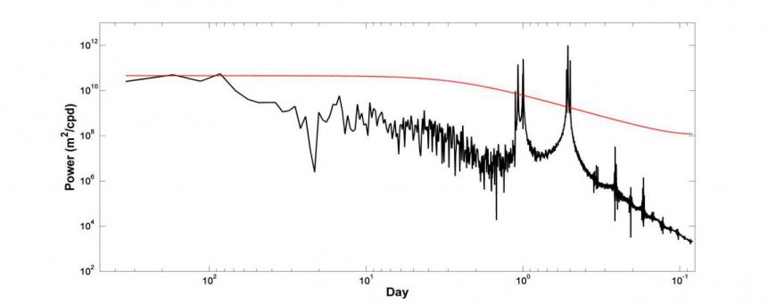
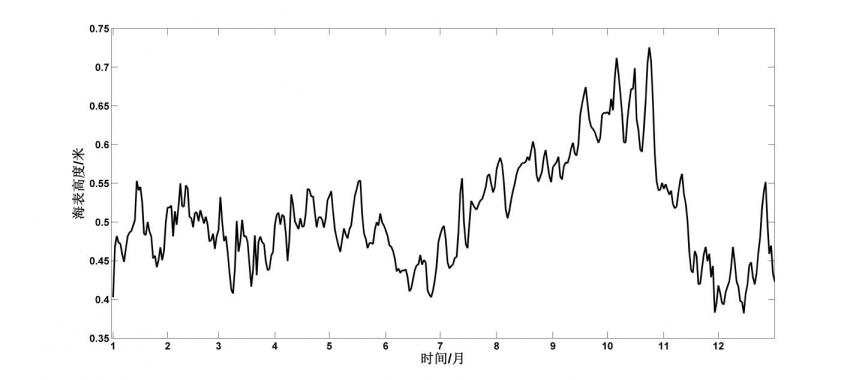
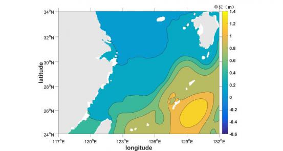
1.The frequency spectrum analysis in the East China Sea region shows that there are 0.5day, 1 day, and 90 day cycles. This mainly reflects the daily signal and seasonal signal of the sea level changes in the East China Sea. And it can be known from the time-series map of sea level in 2013 that sea level generally reaches the peak of the year in summer and autumn.High value areas are generally distributed in the northeastern waters of Taiwan.
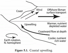
2.There is also a certain relationship between sea-level changes and coastal up-down flow. Under the combined effects of sea surface wind stress, geostrophic bias, and topography, the low sea level along the coast in summer is accompanied by upwelling, while high sea level along the autumn coast is accompanied by downwelling.
3.Mesoscale vortex can cause uneven distribution of sea surface height.The center of the cyclonic vortex is generally lower than the surrounding sea level, and the center of the anticyclonic vortex is generally higher than the surrounding sea level.
4.The sea level of the East China Sea has significant seasonal variation characteristics. This is mainly due to the seasonal changes of the East Asian monsoon, mesoscale vortex, and Kuroshio Current.
5.Due to the effect of geostrophic bias on the Kuroshio Current, the sea level on the right of the Kuroshio Current is significantly higher than the sea level on the left of the Kuroshio Current, and the maximum Sea Surface Height is always present on the right of the Kuroshio Current. This is mainly due to the fact that the more anti-cyclones are on the right side of the Kuroshio.
Key words:sea level changes in the East China Sea, mesoscale eddies, East Asian monsoon, Kuroshio, up-down flow
1.引言:
1.1研究意义
海平面变化是指海洋表面的水位高度发生变化,海表面发生升降起伏运动,即海表高度的变化,研究发现有很多原因可以显著影响海平面的变化:1.热力原因:全球气候变暖导致的上层海水温度升高带来的热膨胀效应以及极地冰川的融化;2.动力原因:海表风应力作用、中尺度涡旋作用;3.地质原因:沿海地区城市地壳构造的升降、地形断裂作用等;全球海平面上升会带来一些严重的不利影响,特别是对一些沿海地区会构成极大的影响,严重威胁海地区设施安全,给沿海地区的社会经济发展带来严重的负面效应。
海平面急剧上升可能带来的负面作用有:1.对海岸带构成极大威胁与挑战,破坏海岸带的生态系统;2.加剧了沿海地区土壤盐渍化程度以及海水入侵的风险;3.加剧台风、风暴潮的灾害程度,从而也会带来很严重的洪涝灾害,风暴潮是指在强烈的大气扰动下导致海平面的异常变化的海洋灾害;我国是个海洋大国,坐拥18000km的海岸线以及14000km的岛屿岸线,且在我国东南沿海区域有超过50%的人口以及70%的大城市,沿海区域一般由于便利的交通以及得天独厚的地理位置一般是我国经济较为发达且人口密集的地区,但同时也因为地势低洼以及地质原因是受海平面影响最为严重的区域,缓慢上升的海平面对这些沿海区域造成的负面影响已经不容小觑,特别是当高海平面和台风、风暴潮等海洋灾害相互叠加时,其破坏力会更加强大。如果海平面一旦出现加速上升的趋势,那么将会提前发生我们所预测的各类灾害。海平面变化是低频且很缓慢的,但是这种变化所带来的累积效应却是很致命的,其后果将会不堪设想,从长远来看,当海平面上升后,只是时间早晚的问题,全球范围内都会受到一定的影响(陈美香等,2009)。现在一个值得我们去注意的问题是,虽然总体说来海平面以每年几个毫米的速度呈现上升的趋势,但是由于各水域的海表风场、海温、海流等环境参数的明显差异,使得区域性海平面变化存在显著差异,区域性海平面变化的影响可能比全球海平面变化带来的影响更突出,这就使得我们也要密切关注区域海平面变化的特征(陈长霖,2010)。基于上述原因,区域海平面变化的相关研究正引起国内外很多学者的关注并且成为当今世界全球变化研究区域中的重点研究课题,只有这样,我们才能准确地去掌握海平面变化的趋势,从而对海平面变化作出精准的预测,并且采取有效的预防措施来应对即将可能发生的灾害。
东海为中国东部的四大边缘海之一,其面积仅次于南海。本文所研究的海域范围为24°N-34°N,118°E-132°E,即为图1.1中的红色矩形框内区域,东海水深跨度较大,总体呈现西北高而东南低的特点。东海区域的季风特征也较为明显。与我国东海相邻的东南沿海海区,海岸线较长,港口众多,人口密集,经济发达,但也是受海平面变化影响较大的海域之一,因此本文选择东海为研究海域,希望通过对海平面变化规律的研究,从而掌握东海海平面变化的规律,从而有利于开展防灾减灾工作,将海平面变化带来的负面影响降到最低。
剩余内容已隐藏,请支付后下载全文,论文总字数:21724字
相关图片展示:
