论文总字数:20340字
目 录
摘要: 3
1 引言 4
1.1国内外研究概况 5
1.1.1自然灾害风险区划研究概况 5
1.1.2沙尘暴国内外研究概况 6
1.2研究背景目的和内容 7
1.2.1研究背景与目的 7
1.2.2研究内容 8
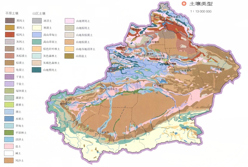
1.3研究区域概况 8
1.3.1自然条件概况 8
1.3.2社会经济条件概况 12
2理论研究与数据 13
2.1理论基础 13
2.1.1沙尘暴 13
2.1.2气象灾害风险区划理论 14
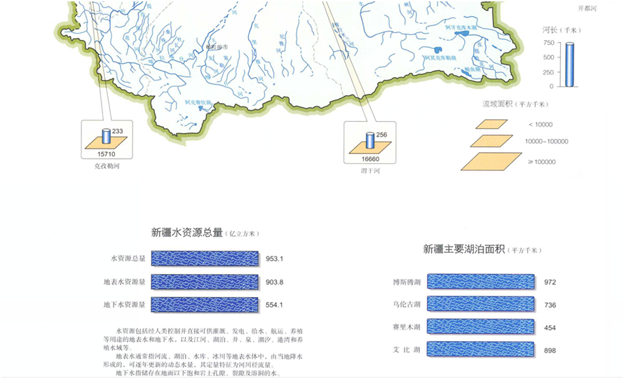
2.2数据来源 15
2.3研究方法 15
2.3.1 ArcGIS空间分析 16
2.3.2植被指数NDVI以及植被覆盖率 17
2.3.3土壤湿度 17
2.3.4土壤可蚀性 18
2.4技术路线 19
3 沙尘暴灾害综合风险评价指标与建模 20
3. 1沙尘暴灾害风险评价指标体系建立原则 20
3. 2新疆沙尘暴灾害风险评价指标体系的研究 20
3.2.1致灾因子危险性指标选取 21
3.2.2孕灾环境稳定性指标的选取 22
3.2.3承灾体脆弱性指标的选取 22
3.3新疆沙尘暴灾害评价指标体系权重确定 23
4新疆沙尘暴灾害风险评估 25
4.1新疆沙尘暴致灾因子危险性评价 25
4.1.1沙尘暴日数月际变化 26
4.1.2大风日数月际变化 27
4.2新疆沙尘暴孕灾环境稳定性评价 28
4.3新疆沙尘暴承灾体脆弱性评价 29
4.4新疆沙尘暴灾害综合风险区划 34
4.5结论与建议 36
参考文献 36
致谢 39
基于GIS新疆地区沙尘暴灾害风险区划
刘松江
,China
ABSTRACT:
Sand dust storm is a kind of meteorological disaster which has a very strong destructive power. It not only brings great loss to the national economy, but also has a great impact on the ecological environment and people's life. China is an important part of the Central Asian dust storm prone areas, is one of the high incidence area of modern global dust storms every year because of the sandstorm disaster caused by the loss of hundreds of millions of dollars. Xinjiang is an arid desert area, low vegetation coverage, a large area of desert and Gobi, is China's sandstorm prone areas, but also the main source of the dust in the north. Ecological environment is very fragile, when the wind transit, very easy to cause sand and dust storms, causing serious losses to the local economy.
Sandstorm disaster risk zoning is the preliminary work of wind prevention and disaster reduction, and it can be used as an effective active hedge measure. As an important part of prevention of meteorological disasters. It is government departments to provide a reliable technical guidance, for urban planning, land use, industrial structure adjustment, and to provide scientific decision-making, can effectively reduce the sandstorm disaster losses.
The in the analysis of Xinjiang, natural and social and economic conditions and historical disaster data based, according to the theory of natural disaster system, from the causes of sand dust storm of scientifically selected gale days number, soil, vegetation coverage and some economic indicators, such as constitutes the evaluation index system of sand and dust storm risk division, reuse analysis hierarchy process (AHP) give different weights to each factor, establishes the fuzzy evaluation model, using GIS spatial analysis were obtained in Xinjiang Province sandstorm disaster by disaster risk factors zoning, disaster pregnant environment stability zoning map and bearing disaster vulnerability map and sandstorm disaster risk zoning map.
Keywords: sand storm disaster; risk assessment; Geographic Information System ;XingJiang
引言
沙尘暴发生时黄沙漫天,大风通过卷起沙粒,以掩埋、侵蚀、风袭等方式,造成农作物减产;同时它能掩埋公路,阻碍交通,刮倒电线杆,影响电力和通讯;漫天黄沙,能见度低,容易造成人员和牧畜的伤亡和失踪;大风极易造成流动性沙丘的移动,使沙漠化进程加剧。
沙尘暴给人身安全及经济建设带来的损失是十分惨重的,下面给出两个详细的受灾实例[11]:1979年4月9至11日,新疆吐鲁番-哈密地区发生强沙尘暴,人员伤亡72,牲畜死亡2.57万头,失踪1043头,受灾农田45.87万亩,损失粮食80t、饲草3062.5t,损坏房屋14886间,交通及通讯中断100多小时。仅兰新线各站直接经济损失达4281.4万元;1983年4月27日下午宁夏发生强沙尘暴,风力10级左右,最高达12级,持续1天,天昏地暗,飞沙走石,能见度不足20m,伤亡失踪63人,仅盐池、青铜峡、同心、贺兰四县(市)牲畜死亡和失踪达2.8万只,受灾农田200万亩以上。
由此可见,对沙尘暴的研究已经刻不容缓。进行沙尘暴灾害风险分析是一项必要且急切的工作,这对新疆省在沙尘暴防灾减灾方面起到建设性的作用,为农业部门在指导沙尘暴威胁区的建设、耕地利用和管理提供基础依据,为政府和公众做好防灾减灾规划,尽可能减少沙尘暴灾害带来的损失,确保经济社会可持续发展具有积极意义。
1.1国内外研究概况
1.1.1自然灾害风险区划研究概况
目前,国际减灾界认为21世纪他们所面临的挑战有五个方面,其中有关灾害风险问题占3/5。这表明灾害风险区划己成为减灾问题的重要领域。
在国外,灾害研究已经有了很长的历史,灾害风险区划开始于20纪中后期。60年代以前,侧重于灾害机理、形成条件、活动过程和灾害预测几个方面的研究。70年代后自然灾害评价工作正式兴起。在实践方面,美国最先进行灾害评估,先后对加利福尼亚州和旧金山海湾地区进行了自然灾害风险区划;在理论上,Blaikei等从致灾因子、孕灾环境和承灾体综合作用的角度,提出承灾体与致灾因子综合作用的致使灾害的发生[34]。进入80年代,包括日本、英国在内的多个国家率先进行了沙尘暴、台风和海啸等方面的气象灾害评价。90年代以来,灾害风险分折与风险管理工作在防灾减灾中的作用和地位日益凸显,特别是1991年“国际减灾十年”科技委员会在一次会议报告中提出灾害评估应该作为重要课题予以关注,此后世界各国都加大了灾害评估方面的研究,灾害评价成果也迅速增多。
我国气象灾害风险评估工作最早始于1950年,其中以洪涝和干旱等灾种为主要研究对象。最初研究主要侧重于灾害的自然属性,80年代以后,灾害的社会经济属性逐渐引起普遍关注。90年代以来,灾害损失与影响研究逐渐发展起来,同时灾害社会属性研究的范畴和灾种类型不断扩展。
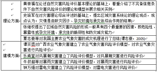
在自然灾害评价理论和建模方面,我国学者提出了不少观点[1](表格1)
表格 1 灾害风险区划理论和模型研究
1.1.2沙尘暴国内外研究概况
国外早在20世纪20年代,开始沙尘暴时空分布、成因与结构以及监测与对策方面的研究。进入70年代,开始对沙尘天气与辐射和热量收支平衡问题进行了分析。80年代起,开始通对沙尘试验去探讨沙尘暴的发生、发展和下垫面特征、地形等对沙尘暴起沙、输送和沉降等的影响。90年代开始,从控制风蚀的角度研究如何控制沙尘暴发生以及利用气候因子建立综合气候影响指数模型。
剩余内容已隐藏,请支付后下载全文,论文总字数:20340字
相关图片展示: